
We have over 25 years of experience using standard and custom-developed GIS and
image processing software to render, analyze, and animate 3-dimensional surfaces
and spaces. These techniques let you see, interact with, and understand your data
on an intuitive basis, using your innate expertise developed through a lifetime of
navigating and comprehending the real 3-dimensional world of surfaces, shadows,
and spatial relationships. Not to mention that they just look cool...
Animation: Paleoclimate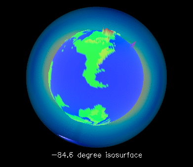
Click image for animation (1.2Mb)
This animation shows the summer temperature isotherms from a climate model of the earth shortly after the breakup of Pangea (about 200 million years ago). Each frame of the animation shows the shape and location of the "surface" within the atmosphere where the temperature is constant at some value (displayed in the caption of each frame), going from coldest (in the upper-mid atmosphere, not at the top!) to warmest (at the surface). Both the atmospheric thickness and the topography are grossly exaggerated vertically to make it easier to see the structures. Colors of the land surfaces indicate elevation; colors of the isothermal surfaces indicate the temperature. |