
The earth's surface is the most fundamental element in virtually all GIS
applications, because it influences or determines most geographic phenomena,
from river networks to road networks, retail sites to recreation sites,
hazardous areas to havens. We have decades of experience mapping, modeling,
analyzing, and visualizing terrain from local to global scales. We
have developed expertise and custom tools for solving a wide range of applied
challenges involving the earth's surface.
Terrain: Route Mapping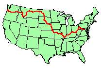
Click to see larger in another window
These images show a project we did for the Lewis & Clark Rediscovery Project, profiling the elevations of the historic expedition on its journey west and back. Given the map-view lines representing the expedition routes, we combined it with a national elevation dataset to obtain the elevations along the route which we delivered back to the project for annotation. The project page with this profile provides additional context and information about the geographic aspects of the expedition. |
