Animation: Simulated Flyby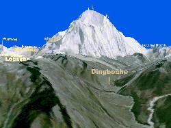
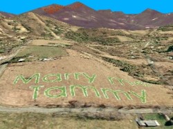
Click image to play a reduced-resolution excerpt from the animation (4.3Mb)
Click image to play a reduced-resolution excerpt from the animation (3.2Mb)
One client requested a flyby along the standard trekking route in the Nepal Himalaya from the airport at Lukla to the Mt. Everest Base Camp, with overnight stops and other points-of-interest labeled. Of course, with simulations there's no reason to stop at the base camp, so the full animation continues up and over the top of Everest and down the Rongbuk Glacier on the Tibetan side. Another client brought us in to design and direct the mapping and cutting of perhaps the world's largest wedding proposal for the television show Perfect Proposal. To assist the production team in visualizing, planning, and filming the whole event, we put together a virtual fly-by animation. We built an elevation model for the site and surrounding areas, and draped it with regional satellite imagery and local high-resolution aerial photography. Finally, we altered the aerial image at the proposed site to give an idea of the size and visibility of the proposal. |