
GIS provides the framework needed to identify the optimal site(s)
for facilities or activities such as store locations, warehouses,
service centers, drilling sites, municipal facilities, wireless
communications towers, recreational facilities, habitat protection
zones, and so on. You provide the criteria, we provide the results.
Location & Allocation: Wireless Mapping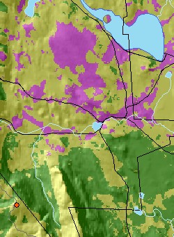
The image shows a portion of a single-antenna coverage map, with the antenna shown as a red dot on a hilltop in the southwest corner. Magenta areas indicate locations with line-of-sight visibility to the antenna, including forest effects but not buildings. Light green areas are forested areas visible to the antenna; dark green are forested areas not visible from the antenna. |